MIDLAND RAILWAY


Camden Road, Haverstock Hill and Finchley Road are three closed stations are on the Midland line out of St.Pancras.

All fell victim to competition from tube lines, buses and trams. The additional benefit of closing them was that it speeded up train traffic to the suburbs. This trend occurred with most inner city stations on main lines.


CAMDEN ROAD

(1868-1916)


Camden Road was closed as an economy measure during the first world war and never reopened.
It is not hard to imagine why: it was too far from the city centre to attract commuter traffic, it wasn't located in the most strategic position, and potential residential traffic would probably not find the short trip down to St.Pancras to be of much benefit (unlike the greater reach of nearby Camden stations on the North London and Northern lines).


The location of the station as arrowed. The Camden Town station seen at the bottom of the map is the Camden Road station of today on the North London Line. It was renamed in 1950.


The location of Camden Road, viewed from the rear (Bartholomew Road). The spacing between the tracks for the platforms is still apparent. A garage was built in the space vacated by the demolished station building. Its roof can be seen on top of the bridge (which is carrying Camden Road over the tracks).

(Oct 2008)


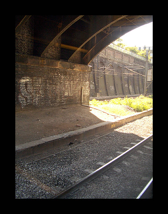
View from a northbound Thameslink train looking north, passing the platform area.

(Oct 2008)


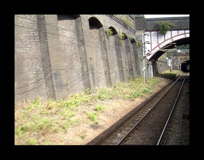
View from the same train but facing south. The new track visible next to the train is new track stored on the former platform area awaiting installation.

(Oct 2008)


The garage that was built on the site of the station building on Camden Road. The garage has since been rebuilt and re-opened.

(Oct 2008)


HAVERSTOCK HILL

(1868-1916)

One of three closed stations on the Midland line out of St.Pancras, the three being Camden Road, Haverstock Hill and Finchley Road.
All fell victim to competition from tube lines, buses and trams. The additional benefit of closing them was that it speeded up
train traffic to the suburbs. This trend occurred on most inner city stations on main lines.


The paltry remnants of street level evidence. This is likely to have been an access structure built subsequent to the station building being demolished (which survived until the 1960s at least). This location, Lismore Circus, was designed in the 19th Century to have elegant streets radiating from it. Now it has the Gospel Oak council estate.

(May 2005)


Inside the access structure above, not looking like one could access anything through it.

(May 2005)


Track level looking toward the St.Pancras direction.

(May 2005)


Opposing view from the photo above.

(May 2005)


Some new and vicious looking security fencing has been attached to the walls at surface level here.

(May 2005)


(Sep 2006)


FINCHLEY ROAD (MIDLAND)

(1868-1927)


The station had a crescent-shaped forecourt at pavement level, with an arc of little shops on each side. In the middle was simply a gateway, which somehow or other had the name of the station or railway or the MR initials over it.
 
In the gateway was a pair of simple wrought iron gates, then a flight of steps down to a terrace say half way between the street level and the platform level (where there is still a rough mound now). The station building was built on this terrace, was quite a large building of red brick with a hipped slate roof and large Italianate looking eaves brackets like the old MR station at Kentish Town. (A very sad loss, that one.)
 
As far as I remember from old maps seen maybe 30 years ago (so not to be quoted!) the original station had a pair of side platforms on the pair of tracks to the south, these were then replaced by another pair of side platforms north of the station building, when the extra pair of tracks were added to the north. Certainly the northern pair of platforms were the last ones in use and had a footbridge crossing the tracks at around the level of the station building.
 
The station building, the terrace retaining walls and the footbridge abutments were bulldozed all of a sudden in about 1980, just leaving a rough mound where they used to be. The signal box at the end of the platforms, between the two pairs of tracks, survived a little bit longer, and the forecourt shops I would think quite a number of years longer. 

Richard Constable
(Aug 2009)


The station forecourt in the process of being demolished. The left hand side is awaiting demolition but the right hand side, as indicated by the gap, has already gone.

(Mar 2003)


Side view. It is only a short walk northwards from the Metropolitan/Jubilee line Finchley Road stn and is next to the slip road for the O2 shopping centre car park.

(Mar 2003)


Track level. About half of the station building had been demolished when this photo was taken. The rear of the remains are virtually hidden by the right hand overhead support post.

(Mar 2003)


Opposing view from the photo above.

(Mar 2005)


The station viewed from the rear. The layout of the station is slightly clearer from this angle.

(Oct 2008)


Palace Gates - Seven Sisters