WEST LONDON LINE


The relatively short line linking Willesden Junction in North-West London with Clapham Junction in South London has found greater purpose as a freight line, although passenger services are finding favour again, especially as part of the forthcoming orbital London railway. Passenger services were withdrawn during World War II, leading to the closure of all but one of the intermediate stations.


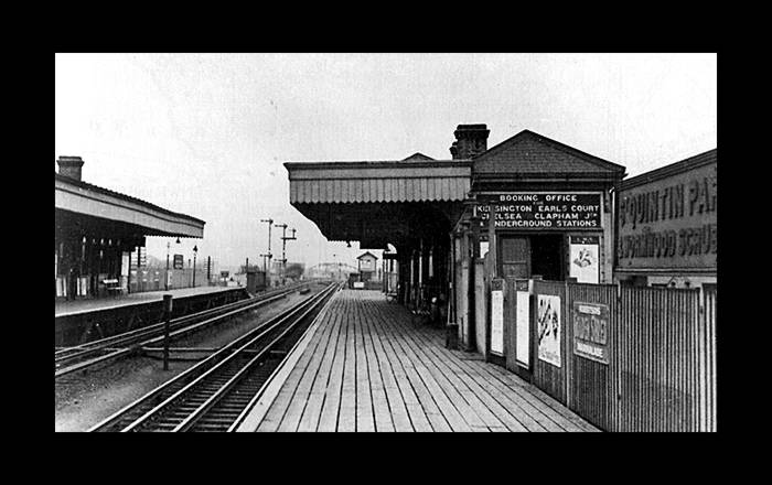
ST QUINTIN PARK & WORMWOOD SCRUBS

(1871 - 1940)


St. Quintin Park station.
The timber construction of the station proved its undoing when it was struck by an incendiary bomb on the 3rd Oct 1940.

These elaborations and reminisces are from Walter Coleshill:

The photograph of the old station is taken looking north; my reasons for stating that is that the ramp from the street connected with the station on the east side that is to say with the building which housed the booking office in the picture.  In addition the signals at the far end of the left hand platform are those controlling: North Pole Junction and Mitre Bridge Junction. If you look carefully at the photograph an upward incline is detectable.  This would agree with the conditions on the ground where the track rises as it nears Willesden.

The station was situated, high on a bank between two road bridges.  They spanned Dalgano Gardens to the North and North Pole Road (NPR) to the South. The only station ramp I can recall started from NPR and ended on the east side (southbound) of the station close to where the booking office was. That is to say on the Bracewell Road side.

There may have been another ramp from NPR which allowed access to the northbound platform but I do not recall it.  Nor do I recall a pax overbridge nor sub-rail tunnel to allow passenger to access the street. It would have been inconceivable for the authorities to allow pax to cross the electrified lines; nor would it have been possible when long, slow moving freight trains where passing through the station.

It is good to see the London rail network slowly (and with encouragement from TfL) to flower again.  This is especially so when I recall that as early as 1875 there were five LNWR services from Willesden (underline next two words) Low Level via Kensington to New Croydon.  These services called at all stations except, would you believe, Wormwood Scrubs.


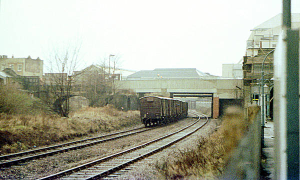
The site of St Quintin Park station facing the other way (i.e. southward). The wide gap between the tracks (as seen in the photo above) is still apparent.

(photo: 2006)


Street level view. The station was awkwardly situated between two major passenger catchment areas, too far away from either to attract much custom.

(photo: 2006)


UXBRIDGE ROAD / SHEPHERD'S BUSH

(1869 - 1940)


Uxbridge Road station eventually closed in 1940 although passenger number had dwindled since the opening of the Central London Railway's Shepherd's Bush station close by (now the Central Line). Curiously then, a new station, this time called Shepherd's Bush, was opened on the same site in 2008 (it is seen here being constructed in 2006).

For photos and details of Uxbridge Road station, see www.disused-stations.org.uk


North of the old Uxbridge Road station (and the new Shepherds Bush station) is this truncated link from the Hammersmith & City line to the West London line. It used to branch off the H&C just south of Latimer Road station (it is still visible on the left just after leaving the station in a southbound direction)

The rest of it was demolished to provide room for the West Cross Route.


WEST BROMPTON

(1866 - 1940 / 1999 - present)


Another closure/re-opening situation is provided here: the original West Brompton station (next to the District Line station but predating it by three years) was closed in 1940 and in this photo from the late 1970s, only the mounds of earth indicate where the platforms were. The station has since re-opened.

For a view of this area a quarter of a century later, showing the rebuilt station and more, move your cursor over the photo.


CHELSEA & FULHAM ROAD

(1863 - 1940)


Southward view.

(photo: 2006)


(photo: 2006)


Northward view.

(photo: 2006)


1930s map showing the close proximity of the West London Line to Chelsea's football ground and the reason why the club recently wanted to have a station opened on the line adjacent to its ground. The application was turned down because of the operational difficulties that would be caused not only by the station but by crowd congestion. This seems a bit odd however: Chelsea FC were willing to contribute toward the cost of a new station and ultimately, the point of a public transport system is to transport the public, no?

Walham Green station seen on the left, has since been renamed Fulham Broadway (District Line)


B
ATTERSEA

(1863 - 1940)


The location of the station. Constructed of wood, there are no remains.

(photo: 2006)


Street level. The station building was situated where the trees are on the left.

(photo: 2006)


The station site is arrowed. The two tracks leading from the West London Line down to Clapham Junction can be clearly seen here: the first of them to branch off leads to the no longer used platform 1, the second track is sometimes used by West London Line trains which arrive at Platform 17.


Reference: London Railways by Edwin Course. B T Batsford Ltd, London, 1962.


Addison Road - Hammersmith Grove Road